Gaumukh-Tapovan | June 18 - 25 | 2022
- Rahul Chakraborty
- Jun 28, 2022
- 5 min read

...Mt. Shivling is perhaps one of the most graceful mountains in India with its unique shape and sheer size when viewed from Tapovan...
Orange alert for weather had been issued in the state of Uttarakhand in anticipation of bad weather. We reached Gangotri (3415m) around 5 in the evening, having started from Dehradun around 7 in the morning. The skies had been overcast throughout. Like every other religious hotspot in the country, we had expected Gangotri to be bustling with activity but due to the incessant rain and bone chilling cold, the community had receded to the indoors. I met our trek leader and guides from Indiahikes, had dinner and ended the day under a warm blanket.
We were supposed to start the very next day (19th June) but chose not to risk it amidst the abysmal weather conditions that were being reported, instead we decided to spend a buffer day at Gangotri itself for acclimatization. However as the day progressed, signs of bad weather did not show up, so we decided to go on a short hike to a nearby cave called Pandav-gufa where rumors had it that the Pandavs had stayed a few days. Itinerary for the day included spending some time gawking at the beautiful Suryakund, lying flat on our backs in a forest clearing staring at the clouds and being treated to a cup of coffee by the Baba who now occupied Pandav-gufa. The mountains that surrounded us were rugged and stony with little patches of green here and there, these patches were mostly composed of pine which the locals used as a source of timber.

Suryakund
We started our journey the next day from Gangotri to Chirbasa (named after the Chir Pine that grows there), located at an altitude of 3580m. The climb was gradual with undulating terrain. Took us around 7 hrs of walking alongside the Bhagirathi river to reach Chirbasa with nothing noteworthy happening along the way except us stopping to have our packed lunches. The camping paraphernalia was being carried by porters who were carrying almost 60Kgs of equipment, tents and kitchen-ware each. We had some tea at a small dhaba (more of a shack, the only one in a 10km radius) just before reaching Chirbasa, giving the porters time to catch up and start assembling some of the setup. From the dhaba, we crossed a small forest section that, we later learned, the locals avoided during night due to the presence of brown bears. We pitched our tents and settled in for a rainy evening, tired from the long day of walking. Chirbasa was located on the banks of the Bhagirathi river and one could enjoy clear views of the Bhagirathi Sisters from the campsite, provided the skies were clear.

Bhagirathi Sisters as viewed from Chirbasa
The trail was easy and short the day after, we had to climb to Bhojwasa, situated at an altitude of 3775m, and it took only a few hours. We had all been handed heavy duty safety helmets for the rock-fall sections on the trail on our very first day. This was the first day they were put to use. Rock-fall sections are sections of the trail where there are loose rocks on the mountain side which are prone to coming loose and falling. Sudden rockfalls are caused by a certain species of sheep known as Blue Sheep (named after the blue patches on their faces and hips, localy known as Bharal) which live in packs on the higher slopes. I was alerted by a sharp pain on the upper part of my left arm caused by a rock the size of a human fist. Looking up the slope I found the culprits responsible looking down at me!

Blue Sheep near Rockfall Section
Bhojwasa was situated on the banks of the Bhagirathi river, it was a windy campsite due to the absence of trees. That night the sky was especially starry, having left my tent around 10pm for a short while I was dumbstruck by the sight of the core of the Milky Way stretched across the night sky. I remember having switched off my headlamp and just standing there and staring for some time.
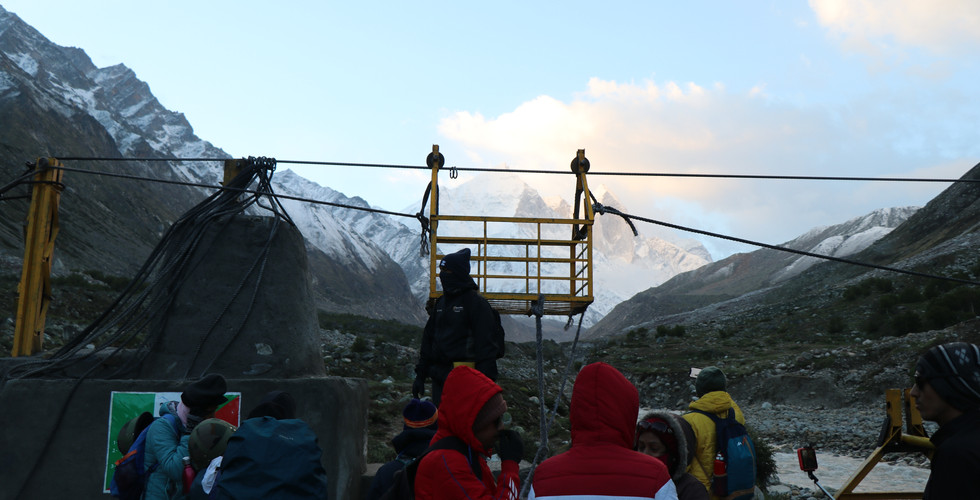
The next day was Tapovan day, the grueling climb that we had all heard about and dreaded from day one. Hike began around 5am in the morning, we had a light breakfast, packed our lunches and prepared for the river crossing session. Bhagirathi had to be crossed using a wire-trolley system that had been established by the government after the usual route to Gaumukh was wiped away from the cloud-burst at Uttarakhand.
River Crossing (Wire-Pulley-Trolley)
The long day's hike began once we were all on the other side. The terrain changed quickly, at times we were walking on boulder ridden grasslands, at other times on sandy river-valleys and yet other times on glacial morraine. The final ascent was very steep (60 - 70 degrees) and rockfalls were frequent. The Gaumukh Glacier was visible below and kept us company throughout our climb. Fast flowing rivers had to be crossed jumping on rocks which were wet and slippery, sometimes on all fours. Halfway up the slope, we were taken aback by a loud rumbling noise echoing across the glacial valley. To my ears it sounded as if some huge boulders on the higher slopes had come loose and were hurtling towards us. I cant remember being more scared ever before. Then, to our relief, 2 HAl Tejas aircrafts, our home made, delta-winged, light-multirole fighters emerged from a corner and swept past the Gaumukh Glacier at lightning speed.

River Crossing en-route to Tapovan, overlooking Gaumukh Glacier
We reached Tapovan, 4463m, around noon and the sight of Mt. Shivling against a clear blue sky was mesmerizing. Flanking Shivling from the right was Mt. Meru, the famous central shark-fin of which was unclimbed until as recently as 2016 when famous American climber Jimmy Chin completed it after years of preparation.
Mt. Shivling (left) , Mt. Meru (Right)
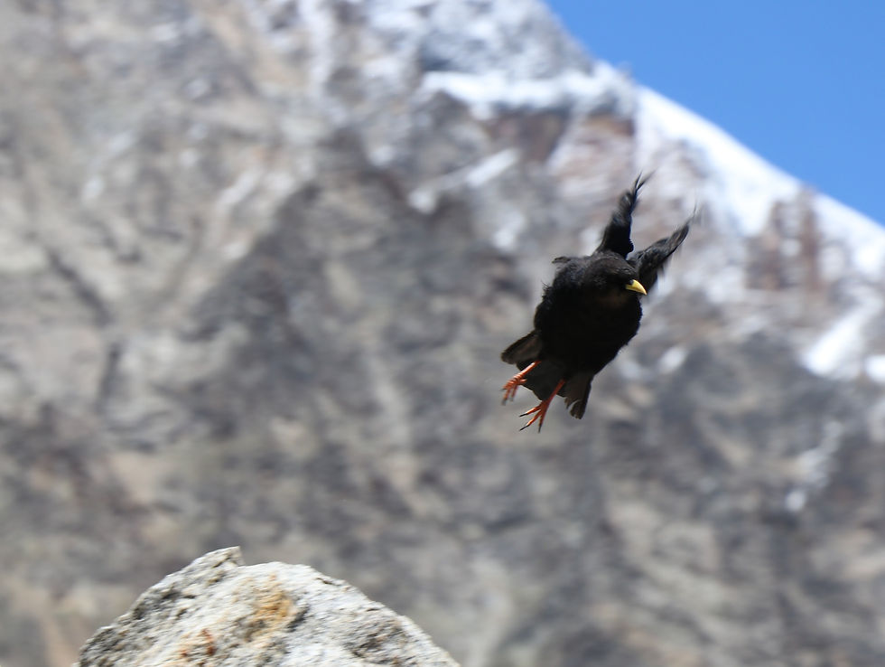
Tapovan was infested by a species of yellow-beaked birds known as the Alpine Chough which did not fear humans in the least. They were more than willing to eat out of your hands provided you had its favorite food, Kishmish!

Alpine Chough
It was a starry night again at Tapovan, I made my very first attempt to shoot a star trail at that altitude. I had been preparing for this shot for at least 2 months and will talk more about it in a different post. Next morning we visited the memorials of climbers who had died trying to scale the North face of Shivling. The most recent one being an Austrian couple who had fallen into a crevice only 100m from the summit of Shivling.
We descended the next day, visiting Gaumukh on our way back and collecting some Gangajal. Tapovan had been an unforgettable experience, from the dew freezing on our tents due to sub-zero temperatures at night to drinking the translucent water of Akash Ganga that flowed there. The trek is not easy and having some prior experience is encouraged.


Picturesque piece to read!
"I was alerted by a sharp pain on the upper part of my left arm caused by a rock the size of a human fist. Looking up the slope I found the culprits responsible looking down at me!"
I laughed way too hard when i saw the photo of the sheep looking down at you xD
A very well written piece ❤️